This is an update from Romain Casalta, whom has been a significant contributor to the effort of finding more answers regarding the disappearance case of Kris Kremers and Lisanne Froon. In addition to his numerous expeditions in the mountains of Panama, Romain has also connected with locals about the case, published articles about his experiences, mapped the region and captured valuable drone footage.
Although the disappearance happened nearly 10 years ago, Romain’s unwavering quest for answers has led to his pursuit of yet another expedition later this year, in 2025. In Romain’s update below he discusses his expedition plans, the article he published in Panama’s most well-known newspaper and some insights on a documentary he’s been working on.
Romain’s Update
Two years ago, I completed my most recent trip to Panama – a trip that was perhaps intended to be my last. I was rather disappointed not to have found the location of the night photos, especially after I invested so much and after observing how much the terrain had changed over the years. It may seem trivial, but when I observed the vast changes in terrain at the location of photo 508, I realized that finding the night photo location may be an impossible task.
It only takes a quick look at the changes in the terrain to realize how the area is vastly different than it was when Kris Kremers and Lisanne Froon disappeared. The area is now virtually unrecognizable as seen in the following pictures.

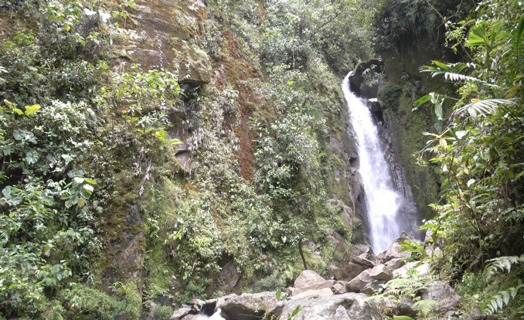
Here is another picture at the location of Photo 508, looking upstream:
Due to the constant shifting in the terrain since 2014, the trail itself has also moved which has resulted in the trail being relocated upstream between 10 and 20 meters (33-65 feet) from where it originally was in 2014. This change made it much more difficult to find the location of where Photo 508 was taken. The trail wasn’t even in the same place as it was approximately 10 years ago. I had already passed the 508-Photo location without realizing it. I had to be shown the precise location to be confident that this was the right place. It was very different, namely because of a landslide that took place in 2019, which completely diverted the trail. In the original photo 508 taken by Lisanne Froon the visible trail path had collapsed, and vegetation inevitably covered the trail and the area surrounding the trail.
I was already aware that a landslide had taken place because the terrain upstream had visible signs of a landslide, but I didn’t realize the scale of impact it had on the trail. While exploring it became clear that these small landslides are frequent.
Finding the Night Photo Location
After observing the significant changes of the trail in broad daylight, I had to ask myself: “If the location of photo 508 was so difficult to identify while searching during daytime, wouldn’t it be substantially more challenging, if not impossible, to identify the location where the night photos were taken?“
Imagine how difficult it would be to find the precise location of the night photos, especially assuming the numerous changes the area has undergone over the years. Photos 508 was taken on the trail, during daytime, with some large rock formations that acted as helpful landmarks. In comparison, the night photos were taken with little visibility, with only the light from the camera flash and there were virtually no observable fixed rock formations or landmarks. In the night photos that were found on Lisanne’s camera, there’s no clear indication that the boulders were large enough to maintain their position without shifting.
The rock formations that can be seen in the night photos could shift. And that idea wasn’t very reassuring to me. It’s like searching for moving target in dangerous conditions, without being certain what the original target looked like. In reality, I believe it’s unlikely that the location of the night photos can be found. Perhaps the only exception would be if some identifying artifacts could be found on site, such as the girl’s belongings.
Should I give up in my search? My answer is was mixed.
My investment has been substantial and the probability of finding something, anything at this point, is very low. That’s why I hadn’t originally planned to return to Panama. At least, not without external funding. That’s where things recently became interesting. After reading about my expeditions in Panama, a couple of people that follow my work have reached out to me to explore the idea of funding another expedition. That’s how things have developed as of late.
I’ll discuss my next expedition more in a moment, but first I want to discuss some other fairly recent developments.
Firstly, regarding my decision if I would continue with my pursuits in Panama, I had to consider my previous idea of making a documentary. I’ve started writing the script for a new documentary about the disappearance of Kris Kremers and Lisanne Froon. Eventually, after various script re-writes, I came across a production company that was interested in the project and had a completely different idea for directing it. Originally, I had absolutely no intention of directing the documentary myself in front of the camera. My objective in making the documentary was to give an account of the trail and the surrounding areas. And I had also considered adding some in-depth speculation about the disappearance, similar to the article that I published last year in the newspaper “La Estrella de Panama”.
I was very honored to write the article for the Panamanian press. The article was written in Spanish, however, you can translate the article to English by copying/pasting the link into Google Translate.
The article was prompted by a proposal made to me by the journalist Adelita Coriat after our meeting in Panama City. For those who follow this disappearance case closely, they’ll recognize Adelita Coriat’s name – she published numerous newspaper articles at the time of the disappearance, and she followed the investigations very closely.
Writing the article was a challenging exercise. I was only allotted a limited number of words and there were so many aspects of my research on the trails that I wanted to express. I wanted to clearly illustrate the trail and the surrounding areas, identify many of the possible choices Kris and Lisanne might have had, as accurately as possible, while they were on the trail and perhaps lost.
Link to the newspaper :
https://www.laestrella.com.pa/panama/nacional/expediciones-en-busca-de-respuestas-al-caso-de-las-holandesas-BX6770300
Link to Adelita Coriat’s blog :
https://www.melodijoadelita.com/2024/04/expediciones-en-busca-de-respuestas-al.html
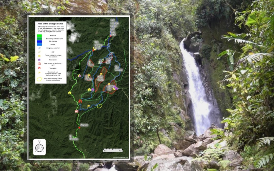
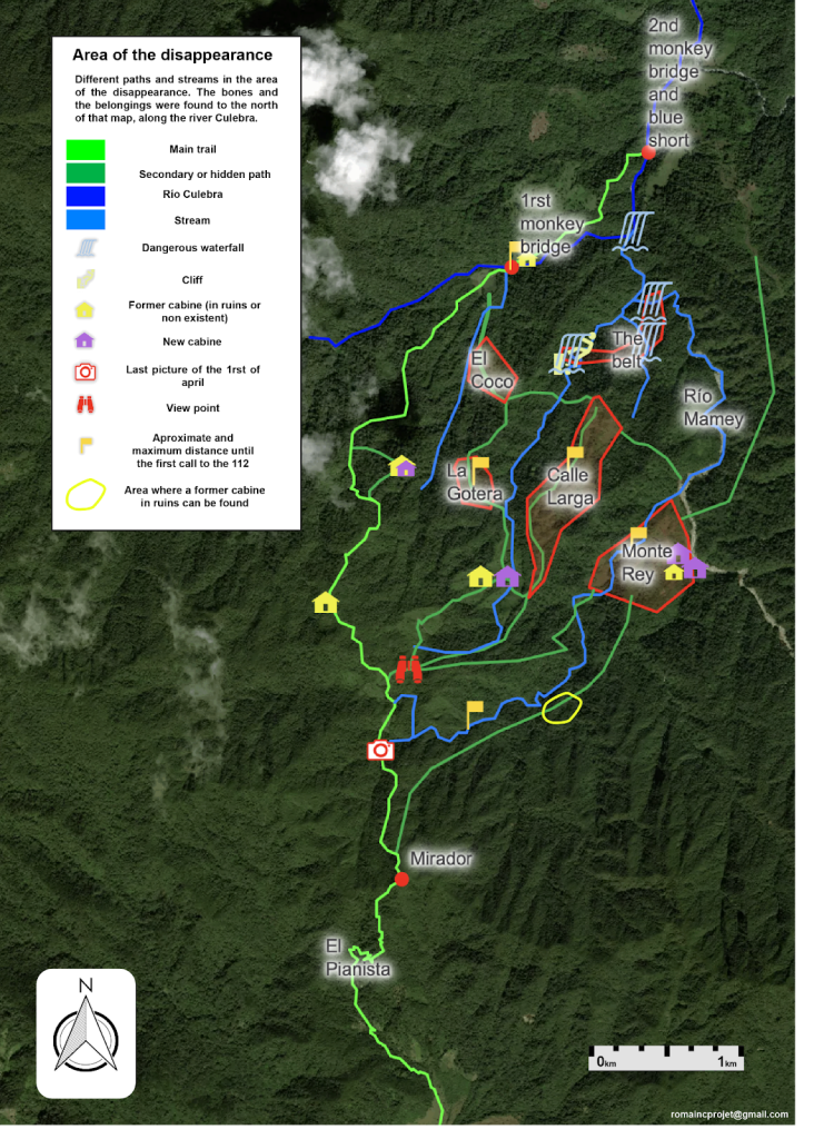
Here is an English version of the published map with minor updates:
Case Documentary Continued
The new direction of the documentary will be to follow my journey during my search for answers regarding the disappearance and its subsequent investigation. It would also provide an excellent opportunity for me to explain my motivations and interest in the case. Put simply, why did I, seven years ago, at the age of 21, a law student in the south of France, formulate the idea to travel to Panama to look into the disappearance of Kris Kremers and Lisanne Froon? Surely not everyone interested in this disappearance case have made such drastic commitments to find answers. So what lead me here?
The production company has also expressed interest in the existing online communities that are passionate about mysterious disappearances. Those online communities could be a discussion topic in the documentary. Also, the creation of a documentary will be an opportunity to showcase the locals who “suffered” the case. Instead of being a documentary solely about Kris and Lisanne, it would be a documentary that encompassed a broader reach of the other people involved in the case, to offer different perspectives and insights.
My documentary project was unlikely to materialize before next year (2026). Between writing the script, writing the production file and the search for funding, everything takes a significant amount of time. What’s more, there’s a great deal of uncertainty, since there’s no guarantee that the channels will go for it. So when some anonymous financial backers expressed interest in my work, I jumped at the opportunity. Another trip. A fifth visit to Panama. This time, thanks to my experience from my previous expeditions, this expedition will naturally be more successful than the others, similar to the 7th expedition, where I went further than any of my previous expeditions.
I can comfortably say that I now have significant expedition experience. I have knowledge of the terrain in the area, I know how to navigate the area, and I have the contacts to carry out a more effective search than in my previous expeditions. Undoubtedly, that doesn’t mean I won’t encounter new challenges. With each expedition there’s always something new. A new problem. A new unexpected scenario. And the solution isn’t always obvious.
For example, during my 6th expedition, there was one unexpected turn of events – while using my drone footage to traverse an area, I thought I was hiking towards a rocky slope. Instead, I found myself facing a cliff. My drone image, which I was relying on heavily to navigate, had led me to believe it was significantly less vertical. Later, during my 7th expedition I was accompanied by a friend local to Boquete. Together, we found a way to descend down the vertical by wrestling through a strip of the trees and vegetation. We were able to descend a small portion of the vertical by using climber’s rope. Situations like that demonstrate that there’s almost always a solution to overcome technical obstacles.


During this upcoming expedition, my primary objective will be to visit a handful of high-priority locations that my sponsors have expressed interest. The interest is in searching potential locations where the night photos may have been taken, although I’m not permitted to disclose the exact areas I’ll be searching.
After completing the objectives of my sponsors, I intend to revisit an area that I had previously explored during a prior expedition. I intend to take more footage of the area, particularly those of a place that bore some resemblance to the location of the night photos, although I wasn’t previously able to identify a location that offered an exact match.
No expedition ever goes completely as planned, therefore I can’t guarantee that this expedition will go as planned. After all, it’s still dangerous, mountainous and therefore a difficult area to cross. I’m optimistic. We’ll see what happens!
With that, I leave you with a new drone video that I haven’t published until now:
In this video, you can see the area where the rivers from the paddocks and Monte Rey meet. The rivers then flow into the Culebra River. This area is isolated by a barrier I call the “belt”, which I referenced in the map (above). In my research, I realized that this barrier was the most complicated area to cross. To the south, very steep slopes and gigantic waterfalls, and to the north, an imposing waterfall. A real trap for the unprepared.
Will this trip be the last? I have absolutely no idea, but I hope so. I hope to get answers and a final conclusion to my quest. I hope my efforts will finally pay off. So many years spent wondering, trying to understand. I want Kris and Lisanne to finally be able to speak their truth. Whatever the nature of what happened to them, the truth is a form of justice that every individual deserves. A justice that Kris and Lisanne deserve.
You can feel the passion, investment and perseverance behind your expeditions.
What you do goes far beyond the simple investigation. You pay tribute to Kris and Lisanne, but also to all the families and local people who have been affected by this case.
This new documentary promises to touch people deeply. I wish you all the best for your seventh expedition. I hope it brings you the answers you’ve been looking for for a long time.
Well done for your commitment!
Seeing this video makes me think that the location of the night photos may be one of those dry, rocky zones just at the side of the rivers … You know that tropical zones have basically two seasons: a dry and a rainy one … So, the so-called “dry riverbed” speculated to be the site of the night photos could be a place just beside a river … The water eroded boulder we can see in photo 550 could be there … But it is not a dry riverbed … Simply, when in the rainy season, the river is wider and covers all those areas around it we can see with rocks in this video … Then an expedition could look in an area of that kind with heavy forest around that matches the photos …
I always think that when they disappeared, it was dry season. And all those small rivers, without water or just a small amount of water, were probably so much easier to walk. And when it started rain, just few days after they started their hike, they had no way to come back.
The night photos where NOT taken in the area where the girls disappeared. Locals would have IMMEDIATELY recognized the unique location. The photos were taken elsewhere by someone else.
I agree. One of the many problems with those night images is that they are being taken somewhere sheltered, somewhere with cover from the rain. That to me tends to rule out one of the big rivers, but what we do see of the location does seems somewhere by Water. If you have a pair of shorts found just down from the 2nd bridge, and you know the two friends had to have crossed the first bridge in theory, then it really would be along a small stretch of the river between the two bridges that these photos are supposedly taken on. But the evidence on the ground really isn’t there to support this being the case…
If Kris and Lisanne had really walked themselves as far as the river and bridge I would be expecting Photograpghs of that journey, some Phone use, but all there is is a huge void between 2pm and 4.30, so whatever Romain’s plans are for his next expedition he would be very wise not to waste much time looking along that stretch of river for inspiration. I think the river is a complete red herring, and he would be better off spending his time researching local knowledge & experience of the area. This is a very old set of trails, many have been abandoned and forgotten over generations, and if you asked around among older people in the area you would gain some real knowledge as to what routes once existed, where they were to be found, and where they led to…
I just don’t know about this Casalta guy. I say 50% chance it was Casalta. 50% it wasn’t. I got more important things to take care of right now.