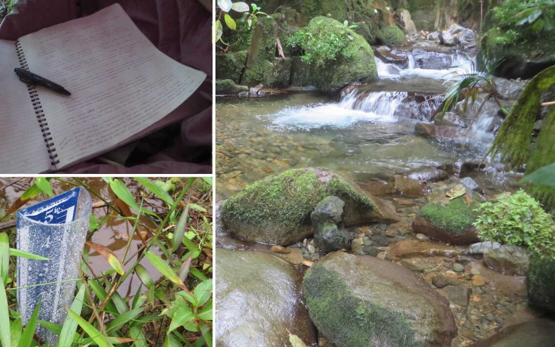
In summer of 2021, the Imperfect Plan team went on an expedition into the jungles of Panama, beyond the El Pianista Trail in northwest Panama, near the small town of Boquete. Our team gathered a lot of information during that trip including GPS coordinates, trail conditions, drone footage, temperature data and other information.
If you’re new to the reading about our case research regarding the disappearance of Kris Kremers and Lisanne Froon, we suggest you check out the Case Articles page. We also suggest you read our article Panama Expedition 2021 – Complete Overview.
Collectively our team has worked together to organize the case information, bring clarity to aspects of their disappearance and make sense of the many unanswered questions.
To this day, nobody knows what happened to Kris Kremers and Lisanne Froon.
Why This Data Is Relevant To The Kremers Froon Disappearance Case
Environmental factors weight heavily on the people’s health, their options, and the decisions they make when they get lost or disappear. Even the temperature difference of only a few degrees can affect a person’s circumstances. The behavior of a person trying to survive will be affected much more by seemingly-unimportant details. For example, cooler temperatures result in increased chance of hypothermia. Similarly, wearing wet clothing can increase the speed of heat loss by approximately 25%. Also, insects are less active when the temperature drops. All physical burden can result in more emotional distress, fewer options and poorer decision-making.
Another important consideration is that sometimes subtle environmental factors can affect the outcome of investigations and forensic reports. This means that small details are sometimes very important.
Our team was not certain which information would be important, so here we’ve published all of the information that we collected and analyzed the ways in which it appears to relate to the case.
Limited information exists regarding their disappearance.
When I originally wrote the article Kris Kremers Bleached Bones – Deeper Insights I didn’t anticipate how many paths that late-night research could lead me. But I went down each “rabbit hole” in order to have the best possible understanding of the conditions that Kris and Lisanne faced.
Since limited information was publicly available from forensic investigators about Kris and Lisanne’s case, I decided to focus that previous article on the few pieces of case information that did exist and correlate those pieces to any other relevant information that I could find, such as environmental variables. I looked at rainfall data, climate data from nearby cities, research studies on decomposition, potential threats in the jungles, and many other factors.
There was also insufficient environmental data. So we chose to gather some important data on the trail.
The Continental Divide is the mountain range in northwest Panama where Kris Kremers and Lisanne Froon went missing. Environmental data from this region of the Continental Divide is very limited. In one instance, for example, before I had access to the police reports I had to rely on some data collected by Fortuna Forest Reserve, a protected nature reserve located 17 kilometers (11 miles) east of where Kris and Lisanne had disappeared. Although the information from Fortuna is highly accurate and reliable (recorded by credible climatologists), Fortuna was far enough from El Pianista for me to question the relevance of its temperatures on the Pianista Trail. Also existed the likelihood that the differing shape of the mountain range’s northern-facing slope could promote rainfall variances between both locations.
In order to rectify this lack of information, our team decided to collect as much data as we could during our expedition, without sacrificing attention to our other important tasks.
I knew that this information could prove to be useful in more ways than one. I hope to illustrate this point in my analysis below.
Data Collection Tools
We used three primary tools to collect the temperature and rainfall information:
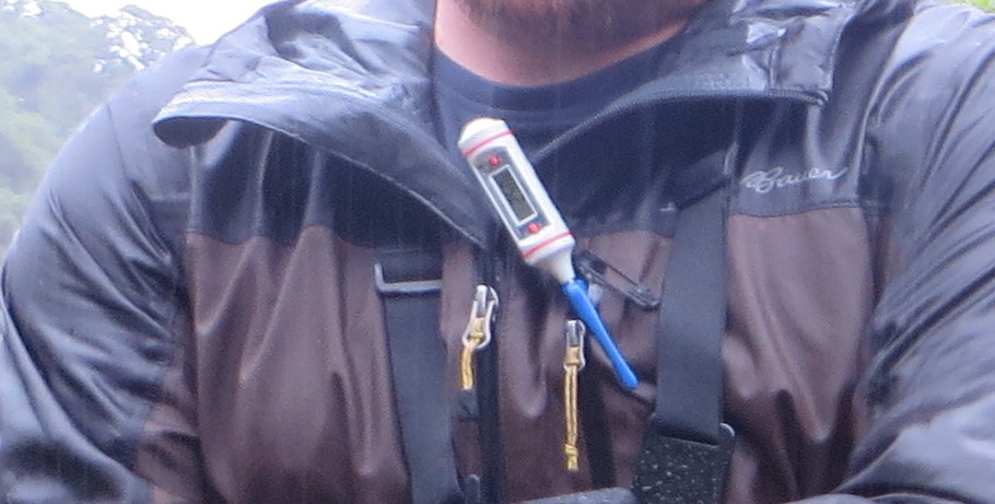
Scientific Temperature Gauge
Model: Control Company 4052 Traceable Long Stem Thermometer
Purpose: Collect air temperature and river temperature.
Notes: In order to get the most accurate temperature readings possible, we opted to purchase a scientific thermometer. The “traceability” of a thermometer ensures that it is calibrated properly and gives consistently accurate results. Common household cooking thermometers are known to be inaccurate.
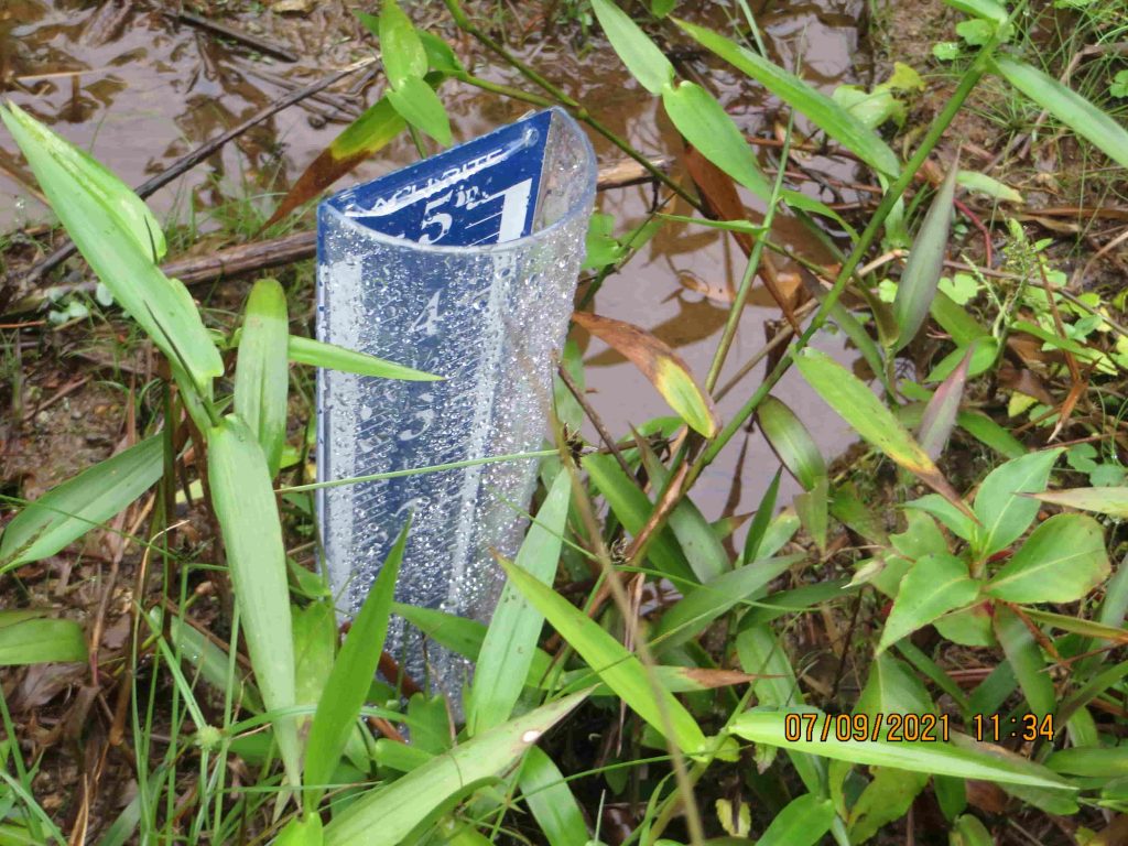
Rainfall Gauge (2)
Model: AcuRite 5″ Capacity Easy-to-Read Magnifying Acrylic, Blue (00850A2) Rain Gauge
Purpose: To collect and measure rainfall.
Notes: We opted for this model for a few reasons: heavy-duty plastic, relative lightweight, the helpful ground-spike and it’s low-profile. We’d be leaving the gauge in the jungle and wanted it to be discreet. We brought two rain gauges and placed them carefully in locations that had no possibility of being affected by overhead trees, nor other hikers.
Standard Measuring Tape
Model: Soft Tape Measure for Sewing Tailor Cloth Ruler, 120-Inch Extra Long Flexible Ruler
Purpose: To measure river depth and width before and after rainfall.
Notes: We purchased this vinyl measuring tape to save on weight/space. After we arrived at River 3, we fastened the measuring tape to a straightened pole (crafted from a straight tree branch) in order to measure river depth. Although the measuring tape is “flexible”, it does not stretch and therefore did not distort the measurement readings.
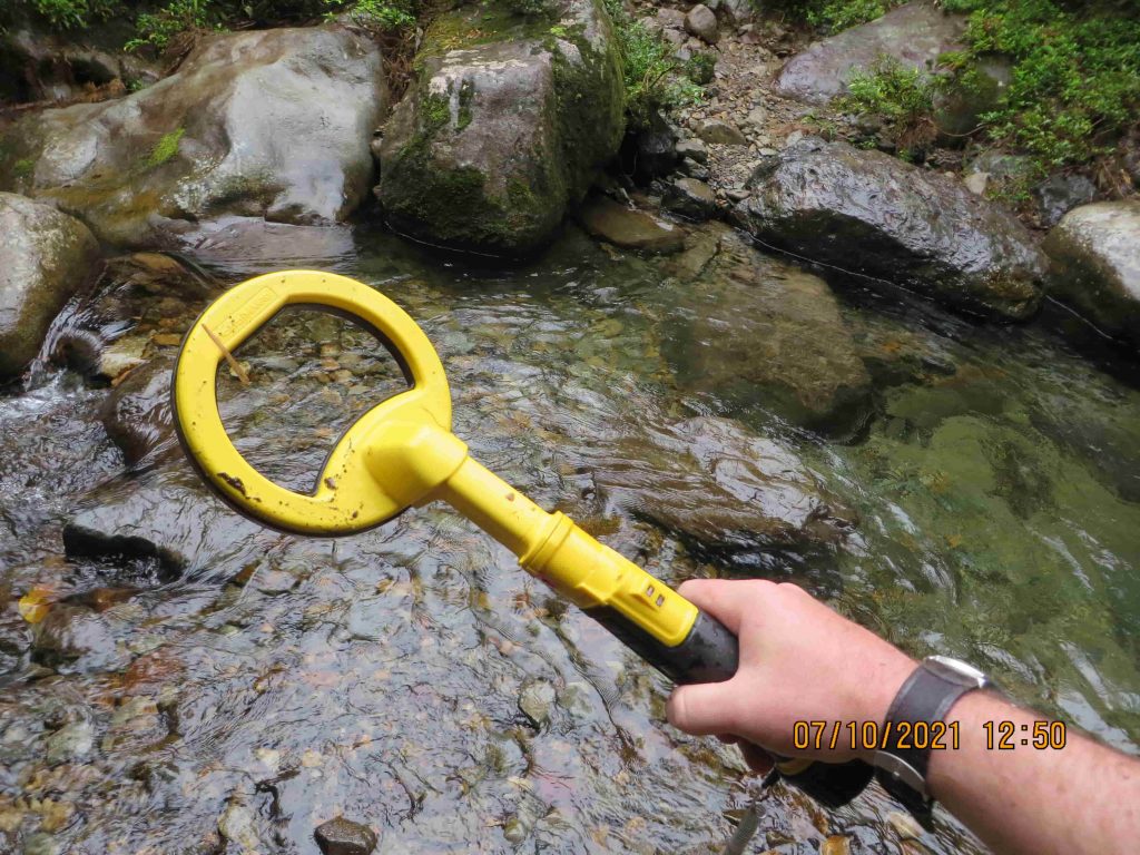
Metal Detector (For a Secondary Effort)
Model: Nokta PulseDive Underwater Metal Detector & Pinpointer 2-in-1 Set with 4″ Coil
Purpose: To search for metallic items in the river and surrounding areas.
Notes: This is a light weight, collapsible handheld metal detector. It’s certainly not the best metal detector on the market, but it was durable, cost-effective and lightweight for our needs on the trail. Unfortunately this metal detector did not have the ability to isolate specific metal types, which may have been helpful. More on that below.
Temperature Data Collected
One goal of collecting temperature data was to approximate the air temperature at the time that Kris and Lisanne disappeared. To do that, we needed to see if a relationship existed between the information we gathered on the trail vs the publicly-available temperature information. If we could identify a relationship, we’ll be able to refer back to the public temperature data from 2014 to extrapolate the approximate temperatures.
In simpler terms, our new temperature data assisted us in estimating the air temperatures in the same region when Kris and Lisanne went missing.
The table below shows all of the temperature data we recorded during the trip.
| Sample | Collection Date/Time | Temperature Reading | Air/River | Location | Notes |
|---|---|---|---|---|---|
| 1 | July 07 – 07:55 | 16.6° C | Air | 1st Camp Site | |
| 2 | July 07 – 09:20 | 16.2° C | River | River Near 1st Camp | Variance: 0.4 |
| 3 | July 07 – 10:50 | 15.7° C | Air | Mirador | Overcast, Windy, Very Foggy |
| 4 | July 07 – 12:32 | 17.5° C | Air | River 2 | |
| 5 | July 07 – 12:32 | 16.5° C | River | River 2 | Variance: 1.0 |
| 6 | July 07 – 13:06 | 18.9° C | Air | River 3 | Sunny. Highest Temp Recorded. |
| 7 | July 07 – 13:06 | 17.0° C | River | River 3 | Variance: 1.9 |
| 8 | July 07 – 20:53 | 16.8° C | Air | 2nd Camp Site | High moisture, thunder/lightening. Light rain between 7:00-8:00 PM. |
| 9 | July 08 – 10:51 | 16.8° C | Air | River 3 | |
| 10 | July 08 – 10:51 | 16.5° C | River | River 3 | Variance: 0.3 |
| 11 | July 09 – 14:36 | 16.4° C | River | River 3, Near River Split | |
| 12 | July 10 – 17:00 | 16.4° C | Air | River 3 | |
| 13 | July 10 – 17:00 | 16.2° C | River | River 3 | Variance: 0.2 |
| 14 | July 11 – 04:25 | 14.8° C | Air | 2nd Camp Site | Noticeably cold night. Lowest Temp Recorded. |
Immediately it became obvious to us that the high elevations of the mountains have much cooler temperatures than the hot and humid temperatures at lower elevations.
I specifically recorded the temperature (14.8° C, 58.64° F) on July 11th, at 4:25AM, because I woke up shivering in my hammock tent. While sleeping I was wearing a light merino wool half-zip sweater, wool socks, light pants, all of which were completely dry. I slept in my Snugpak Jungle Bag (sleeping bag) which was partially (50%) unzipped. After zipping it up, I was able to fall back asleep comfortably. Romain had also noticed it was particularly cold that night.
From the information above, we were able to identify the following metrics, which will be helpful in our comparisons to the data available during the time of Kris and Lisanne’s disappearance:
| Data Points | Calculation | Notes | |
|---|---|---|---|
| Average Daily Air Temperature: | 7 | 16.957 | Does not include: Night temps, Mirador Temps |
| Average Daily River Temperature: | 3 | 16.467 | Does not include: River Before Mirador (16.5+16.5+16.4)/3 |
| Average Variance Between River & Air Temperature: | 5 | 0.76°C | |
| Total Air Temperature Range: | 8 | 14.8 – 18.9 | |
| Total River Temperature Range: | 6 | 16.2 – 17.0 |
Note: The “variance” between river and air temperature means that the average river temperature stayed within an average of 0.76°C of the air temperature. This variance would likely be somewhat consistent throughout the year, given that the mountain range is clouded and the rivers have a tree canopy, both of which act as insulators from extreme temperature variances.
We can make a few observations:
- The air temperature has a wider range than river temperature, which suggests that the air temperatures change more rapidly, while river temperatures change more slowly.
- River temperatures remained fairly steady at approximately 16.5°C (61.7°F).
- On sunny days during the afternoon, with little cloud cover, the air temperature can spike at least 1.4°C.
- The mirador, even when sunny, has the lowest temperature in the area, due to elevation.
- Some nights on the trail are uncomfortably cold at least at 14.8°C (58.6°F), especially without long sleeve clothing.
During our expedition, we relied heavily on the freshwater of River 3. Although we had water filters and purifiers, we often didn’t use them and had no issues with sickness. We submerged ourselves in River 3 on more than one occasion, but the temperature was borderline uncomfortably cold. We could only withstand the 16.5°C temperature for about 5 or 10 minutes.
Comparing Temperature To Nearby Public Information Sources
During the time that our team was in the mountains, the following public temperatures were collected:
| Location | Elevation | July 7 | July 8 | July 10 | July 11 | Source |
|---|---|---|---|---|---|---|
| Boquete, Panama | 1,250 M | 25.00 (12:00) | 23.50 (11:00) | 19.30 (17:00) | 17.50 (04:30) | Source |
| Fortuna Nature Reserve | 1,330 M | 19.41 (12:30) | 18.65 (11:00) | 18.56 (17:00) | 17.37 (04:30) | Source |
| Trail Data | 1,620 M | 17.50 (12:32) | 16.80 (10:51) | 16.40 (17:00) | 14.80 (04:25) | (our info) |
For consistent comparisons, I used public temperature data that was logged the same time/day of the data we collected on the Trail. Fortuna Nature Reserve recorded temperature readings ever 15 minutes, with highly accurate scientific tools.
Notable results:
- Compared to Boquete, Fortuna Nature Reserve has a much closer relationship to temperatures on the trail.
- Temperatures are higher in Boquete due to the protection that the mountains offer from the northeasterly trade-winds.
- Boquete is not a reliable comparison to temperatures on the Pianista Trail. Temperature and weather conditions differ.
Because I noticed a strong relationship between our trail data and the data from Fortuna Nature Reserve, I decide to compare all air temperatures, side by side, and find the average difference.
| Sample | Collection Date/Time | Trail Air Temp | Fortuna Air Temp | Difference | Notes |
|---|---|---|---|---|---|
| 1 | July 07 – 07:55 | 16.60 | 18.01 | +1.41 | |
| 3 | July 07 – 10:50 | 15.70 | 18.25 | +2.55 | Mirador. Windy. Foggy. |
| 4 | July 07 – 12:32 | 17.50 | 19.41 | +1.91 | |
| 6 | July 07 – 13:06 | 18.90 | 19.29 | +0.39 | Only day with sunny/clear skies on the trail. Rained slightly at night. |
| 8 | July 07 – 20:53 | 16.80 | 18.27 | +1.47 | |
| 9 | July 08 – 10:51 | 16.80 | 18.65 | +1.85 | |
| 12 | July 10 – 17:00 | 16.40 | 18.56 | +2.16 | |
| 14 | July 11 – 04:25 | 14.80 | 17.37 | +2.57 | Especially cold night. Lowest Temp Recorded. |
| +1.895 | Average Temperature Difference |
Note: I’ve excluded the Mirador and single sunny day in the average because those readings resulted in outliers that skewed the results heavily.
On average, the temperatures at Fortuna are approximately 1.895 degrees (C) warmer than on the trail where Kris and Lisanne went missing. This difference is likely due to the lower-elevation of Fortuna (approx ~300 meters). This comparison gave me a helpful average difference to work with to standardize the temperatures. Additionally, there appears to be a correlation between the rise and fall of temperatures, which is good.
Seasonal Differences
Kris and Lisanne disappeared in April of 2014. Our expedition was in July of 2021. Romain’s alternative expedition was in March and April of 2022. In Panama, April is known to be the end of the dry season, which runs from December to April. The rainy season starts in May, increases substantially in September, then slows by the end of November.
These seasonal changes presented some challenges when comparing rainfall and temperature data. However, Fortuna Nature Reserve’s data was consistent and had a strong correlation to our data. This proved to be beneficial in determining the effects of seasonal changes on temperature. More on that below.
Comparing Temperature To Previous Hypothesis
Before our expedition took place, I had estimated that the temperatures on the trail were between 1 and 2 degrees warmer than Fortuna. That was incorrect. After analyzing the new data we can see that the temperatures on the trail are approximately 2 degrees cooler than temperatures at Fortuna.
Next, I wanted to see if temperature readings per year were fairly consistent across specific days of the year. They were mostly consistent within a couple of degrees. In other words, there were no wild swings in temperature from year to year.
Even with the vast amount of data from Fortuna, the biggest challenge I faced was that Fortuna had only started collecting data in July of 2018 and their most recent publish date was March 10th 2022.
Fortuna Air Temperature Readings Per Year
With the missing 2014 data, my next best option was to run a bunch of numbers on Fortuna. Keep in mind, we had to subtract 1.895 degrees (C) from the averages that I calculated using the temperature variances between locations.
Here’s what I gathered from Fortuna’s temperature readings:
| 2021 | 2020 | 2019 | 2018 | Average | Est. Trail Temp 2014 | |
|---|---|---|---|---|---|---|
| APR 01 – Day | 18.49 | 19.60 | 20.17 | n/a | 19.42 | 17.52 |
| APR 01 – Night | 19.08 | 17.50 | 16.49 | n/a | 17.69 | 15.79 |
| APR 01 – 7-Day High | 21.51 | 23.50 | 21.10 | n/a | 22.04 | 20.14 |
| APR 01 – 7-Day Low | 15.82 | 16.82 | 16.37 | n/a | 16.34 | 14.44 |
| APR 15 – Day | 18.96 | 19.08 | 19.22 | n/a | 19.09 | 17.19 |
| APR 15 – Night | 19.15 | 18.37 | 18.96 | n/a | 18.83 | 16.93 |
| APR 15 – 7-Day High | 24.70 | 23.93 | 22.66 | n/a | 23.76 | 21.87 |
| APR 15 – 7-Day Low | 17.08 | 16.37 | 15.80 | n/a | 16.41 | 14.52 |
| JUN 01 – Day | 18.08 | 21.53 | 21.92 | n/a | 20.51 | 18.61 |
| JUN 15 – Day | 22.11 | 23.09 | 18.68 | n/a | 21.29 | 19.40 |
| JUL 01 – Day | 22.47 | 19.77 | 19.60 | n/a | 20.61 | 18.72 |
| JUL 15 – Day | 19.27 | 22.42 | 21.82 | 18.94 | 20.61 | 18.72 |
| AUG 01 – Day | 18.20 | 23.14 | 18.84 | 22.87 | 20.76 | 18.87 |
| AUG 15 – Day | 20.58 | 20.72 | 21.20 | 19.82 | 20.58 | 18.68 |
So, I created an average based on the last 4 years of temperature data, then added the average difference of 1.895 C.
For a broader view, I also created this graph which shows the high, average and low temperatures per week, at Fortuna, for the same 3 years:
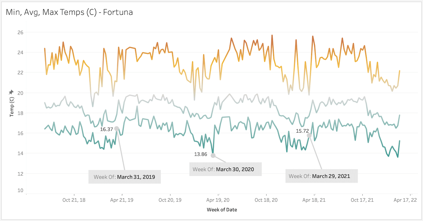
I labeled the lowest temps recorded during the week immediately preceding April 1st. The temperatures in the graph do not take into consideration the 1.895 degree (C) difference. One thing this graph makes clear is that the daytime temperatures and nighttime temperatures have a sizable difference.
From all of this information, we can conclude that Kris and Lisanne probably endured temperatures as low as ~14.44°C (58°F) and as high as ~21.87°C (71.36°F). Average daytime temperatures were approximately ~17.52°C (63.5°F) during the initial days they went missing. These numbers take into consideration both location difference and seasonal difference.
Prior to our expedition, I never would have anticipated that it’s possible for temperatures to drop so low in the jungle. And the high moisture also made me realize that the conditions on the mountain probably would have negatively impacted Kris and Lisanne much more than I had previously thought.
Had Kris and Lisanne stayed on the mountain near Photo 508’s location (their last day-time photo), the low temperatures on some nights would essentially guarantee they would have searched for shelter (or at least desperately needed it), especially considering they were both wearing short-sleeve shirts and shorts.
Without shelter, they would have had only two options:
- Cover themselves in some form of dry vegetation, such as leaves. However, it’s unlikely they could have found dry vegetation due to the moisture, including during April 2014. I’ll discuss precipitation in more detail below in a moment.
- Continue traveling down the mountainside to lower elevations to seek warmer evening temperatures. This would have been their best chance at survival, assuming they were injured or otherwise unable to hike back up the mountain to return to Boquete.
If they were injured and unable to climb back up to the mirador, staying on the mountain would be dangerously cold during some nights. Their only viable option would have been to go down the northern-slope of the mountain to escape the cold night-temperatures of the higher elevation.
Temperatures Recorded At Lower Elevations
During Romain’s separate expedition in March of 2022, he recorded air temperatures at the lower elevation of the Paddock. The average daytime temperatures were warmer, which supports that Kris and Lisanne would have benefitted by going to lower elevations to avoid cold temperatures.
Here is Romain’s air temperature data:
| Sample | Collection Date/Time | Trail Location | Trail Air Temp | Notes |
|---|---|---|---|---|
| 1 | March 22 – 13:42 | Paddock camp | 25.4° C | |
| 2 | March 22 – 13:44 | Paddock camp | 25.0° C | 78% Humidity |
| 3 | March 22 – 17:25 | Paddock camp | 20.0° C | Slight rain earlier. 89% Humidity |
| 4 | March 23 – 02:10 | Paddock camp | 17.3° C | Rain earlier. 98% Humidity |
| 5 | March 23 -13:00 | Paddock camp | 20.0° C | Rain. Warm morning. |
| 6 | March 24 – 02:30 | Paddock camp | 18.7° C | Inside Temp. |
| 7 | March 24 – 10:17 | Paddock camp | 20.3° C | Rain. Inside Temp. |
| 8 | March 24 – 10:17 | Paddock camp | 17.8° C | Rain. Outside Temp. |
| 9 | March 25 – 17:20 | 1st Monkey Bridge camp | 18 to 20° C | After long rain had ended ~14:20 |
Paddocks Camp GPS Coordinates: 8.8535139, -82.41150277777778
Paddocks Camp Elevation: 1440m
1st Monkey Bridge GPS Coordinates: 8.8707778, -82.41827500000001
1st Monkey Bridge Elevation: 1080m
Observations:
- Romain’s highest recorded temperature of 25.4°C (77.72°F) was taken at approximately 1:42PM, which is a substantial increase from the highest recorded temperature during our first expedition.
- Romain’s lowest recorded temperature of 17.3°C (63.14°F) was taken at 2:10AM. This is a 2.5 degree difference from the lowest temperature we recorded 14.8°C (58.64°F) in July of 2021 only 200 meters higher in elevation. However, the seasonal differences make these readings essentially non-comparable.
- At the 1st Monkey Bridge the thermometer reading kept fluctuating to an unreliable degree, therefore the best we can provide is an approximate range.
We cannot draw stronger conclusions from Romain’s recorded temperatures until more temperature data becomes available from Fortuna.
So far this year (2022) Fortuna has only published temperature data through March 22, 2022, so we’ll have to wait until more data is published in order to identify temperature variances, to standardize the temperatures between locations and therefore determine approximate temperatures in 2014 (similar as we did above).
Rainfall Data Collected
Rainfall affects various conditions for a lost person. Heavier rainfall results in increased flooding and a higher chance of injury, especially while in or near rivers. It also results in faster heat loss within the body. Without adequate clothing, rainfall increases the chance of hypothermia during nighttime.
Official Data From Police Reports
On June 24th, 2014 Panama’s officials had requested rainfall data for the months April, May and June. They requested the information specifically for the region of the Pianista Trail, from a company called Empresa de Transmisión Eléctrica (ETESA).
On July 31, 2014 ETESA responded to the request by providing daily rainfall data from 3 collection stations.
Here’s ETESA’s stations, based on the police reports:
| Station | Province | Elevation (m) | GPS Coordinates | Notes |
|---|---|---|---|---|
| Changuinola Sur | Bocas del Toro | 400 | Lat: 8.960556 Lon: -82.424722 | North of Mountain Range |
| Cerro Punta | Chiriqui | 1830 | Lat: 8.866666 Lon: -82.583333 | South Of Mountain Range |
| Bajo Grande | Chiriqui | 2300 | Lat: 8.850000 Lon: -82.550000 | South Of Mountain Range |
Changuinola Sur is the only station that’s found on the northern-facing slope of the Continental Divide, so it’s the most relevant to the case. Also, it’s the nearest available data-source to where Kris and Lisanne had disappeared, being only about 5 miles (8 km) north from where they went missing.
Here’s a map of Changuinola Sur’s precise location: (click to zoom in another window)

Here’s the rainfall data that ETESA provided to investigation officials:
| Day | 1 | 2 | 3 | 4 | 5 | 6 | 7 | 8 | 9 | 10 | 11 | 12 | 13 | 14 | 15 |
| Rain (mm) | 0 | 0 | 3.9 | 6.4 | 7.1 | 0 | 0.3 | 24.5 | 25.7 | 33.6 | 39.3 | 4.8 | 0 | 0 | 5.5 |
The first week that Kris and Lisanne went missing received little rain. It wasn’t until the second week that the rainfall increased, starting April 8th.
On April 3rd, at 02:21 AM, the logs in Lisanne’s phone noted that a weather app was used. The subtle rain observed by ETESA (Day 3 above) may have been the reason that Lisanne attempted to search for weather information. Furthermore, this late-night phone activity suggests concern and loss of sleep.
Our team collected some minimal rainfall data during our expedition, and overall we hardly felt that it was raining. It was more like heavy moisture, except perhaps during only one evening when we heard light raindrops landing on our tents.
Here’s our rainfall data:
| Sample | Date/Time Start Collection | Date/Time End Collection | Precipitation Measured |
|---|---|---|---|
| Sample 1 | July 07 – 13:06 | July 08 – 10:51 (~22 hrs) | 12.70mm |
| Sample 2 | July 08 – 10:51 | July 10 – 17:00 (~56 hrs) | 14.79mm |
| Sample 3 | July 10 – 17:00 | July 12 – 07:42 (~15 hrs) | 06.35mm |
Overall, the precipitation data that we recorded on the trail isn’t particularly helpful when compared to the data provided by ETESA in the official police report. However, our data gave us a reference to how many millimeters of rain equates to “light precipitation” in the jungle.
ETESA’s report illustrated that April 8th through April 11th had a medium rain, which is certainly enough for clothing to be soaked within an hour while outdoors, but it’s still not a heavy downpour. According to ETESA’s rain data, the first heavy rain of 2014 happened on May 10th when the station recorded 89.6 mm (3.5 inches) of rain.
Flooding
We knew that flooding is common in the region. A local also confirmed it in the police report: “…the climate in the region has low temperatures and is rainy…” and “…the active currents and floods are not predictable due to the different rains of the season…“.
During our expedition, the only way our team could reasonably observe the rivers was by walking in the river themselves. And we fell more than once. Walking in the rivers is dangerous.
If Kris and Lisanne had gotten lost or injured and attempted to travel downstream, their chance of an injury would have increased substantially due to slippery rocks and unpredictable flooding. As the water accumulates at higher elevations, it has nowhere to go except for down the mountainside, into the turbulent rivers downstream. Furthermore, the rivers do not have sandy banks to ease the burden of walking.
Rising River Levels Based On Rainfall
Even with the minimal rainfall that our team experienced, we observed rising river levels during our expedition.
We determined River 3 to be of importance for more than one reason. For more detail, refer to the main expedition article. Additionally, the GPS coordinates where River 3 intersects with El Pianista Trail can be found on the Maps & Coordinates page.
We decided to collect some basic information about the how much rainfall impacted River 3.
| Time/Date River Data Collected | Depth Pos 1 (left) | Depth Pos 2 (center) | Depth Pos 3 (right) | |
|---|---|---|---|---|
| Measure 1 | July 07 – 1:06PM | 31.50cm | 21.00cm | 31.00cm |
| Measure 2 | July 08 – 10:51PM | 32.75cm | 22.00cm | 32.50cm |
| Measure 3 | July 10 – 17:00PM | 29.75cm | 20.50cm | 29.50cm |
We are aware that a larger sample size would be necessary to determine that our readings were not in some-part due to human error, shifting rocks, or other unknown factors.
If our data is correct, then we can see that little precipitation resulted in changes in river depth. It took only approximately 12 mm of rain to result in a 1 to 1.5cm increase in river depth.
The width of the River 3 stayed consistent at approximately 3 meters wide, due to the steep rocky banks at the edge of the river.
More Observations We Made On The Trail
We noted many observations on the trail that made an impression on how we thought about the disappearance case.
- Starting a fire was not possible. The cloud cover resulted in little sunlight which ensured that the persistent moisture covering all woods and leaves, even when it was not raining. Yann, our guide, confirmed that starting a fire would be nearly impossible. Even with sophisticated fire-starting gear, we could only use our blowtorch to heat our food. To our knowledge, Kris and Lisanne had no methods to start a fire.
- The rivers are loud. The rivers in the area can be heard from a distance away, up to a few hundred meters. Standing near a river is particularly loud. If Kris and Lisanne were near the river, it’s very likely they would not be able to hear a search team walking nearby. Similarly, it would be difficult for searchers to hear any cries for help.
- The trail is frequently travelled by locals. We logged seeing between 5 and 7 locals on the trail each day. We cannot determine how many tourists and locals travelled the trail in April of 2014, although it was considered a popular trail back then.
- Insects are most active during early evening. The insects reach their highest level of activity before approximately 10PM, before the temperatures drop to their lowest levels. Turning on a light during those hours resulted in a swarm of insects. Insects are less active near the rivers, including at night.
During the expedition, our team learned how nearly-impossible it is to maintain any reasonable level of comfortable in the jungle. It was very difficult to simply stay dry, even with the little rainfall we experienced and with adequate protective clothing, backup dry clothing, a heat source, and other life-sustaining essentials.
Yann, our guide from Survie Jungle, taught us how to rotate our clothing to ensure we always had dry backup clothing. But once clothing got wet, it stayed wet. We learned that quickly.
Romain’s Weather Observations
When Romain visited the trail in March and April of 2022, he observed that the trail had high levels of moisture, similar to our expedition in July of 2021. He had to pass a lot of mud and conditions were much the same. In fact, two or three days prior to his 2022 expedition he noted a “huge rainstorm” that delayed his expedition. During his time on the Paddock, he also experienced a lot of rain.
At one point, during his expedition, Romain attempted to dry his socks on a rock near river 3. This demonstrates that during the sunny days on the mountain it’s possible to dry clothing. Unfortunately, Romain’s socks were taken by someone on the trail, and he was unsure whom took them.
How Low Temperatures & Moisture Can Affect Chance Of Survival
Before I continue, it’s important to mention that there are two general schools of thought that attempt to answer why Kris and Lisanne disappeared. Some people believe they were lost or injured. Others believe there was a 3rd party involved in their disappearance.
Nobody knows for certain.
What I’m going to look at in this section is how temperatures and rainfall conditions affect a person’s decision making, especially in the conditions that our team experienced during our expedition. I’m going to work on the assumption that Kris and Lisanne had to, for one reason or another, survive in the elements. Additionally, the following information shows that it would have have been in Kris and Lisanne’s best interest to escape higher elevations in search for warmer temperatures, if they had the option. Therefore, this part will be geared more towards the lost/injured theory, although I’m well aware that alternative theories have merit as well. Again, nobody knows what truly happened. A lot of possibilities exist.
Temperatures That Impair Mental Function
The average healthy-adult body temperature is 37°C (98.6°F). However, a healthy adult often has temperatures between 35.6–36.7°C (96–98°F). Temperatures can vary depending on many factors.
Kris and Lisanne were not in freezing temperatures, nor in temperatures that most people would consider very cold. However, what one would consider to be “very cold” temperatures is not required for a person’s body temperature to drop. Core human body temperatures can drop from even mild temperature differences, especially without food and adequate clothing.
“Symptoms of mild hypothermia, such as shivering, weakness and confusion, set in when core body temperature reaches about 36.7°C (95°F).”
LiveScience – How Does A Person Freeze To Death?
It’s important to note that this difference in body temperature is very small from the average healthy body temperature. This further shows that “very cold” temperatures are not necessary to affect the mental state of a person. Persistent mild temperatures can lower the body’s temperature under the right conditions.
People begin shivering when their body temperature drops lower than between 36 and 35.5°C (97 and 96°F).
“…the normal body temperature’s 98.6. Once it starts to drop down around 97 or 96, you’re going to start shivering. And that’s just your body’s way of trying to produce heat. You shiver. It produces heat. It tries to warm up the core. But the really concerning thing is if you stop shivering. That’s when your body temperature gets less than 90 degrees, and that’s where it becomes life threatening.”
University Of Utah Health – Dr. Troy Madsen – Do I Have Hypothermia, Or Am I Just Really Cold?
As I had mentioned in the temperature section above, I woke up from shivering in my hammock tent during the expedition on July 11th, at 4:25AM and recorded the air temperature at 14.8° C (58.64° F). According to Dr Troy Madsen, this means that my core body-temperature had dropped, even while I was wearing warm dry clothing, nestled in a sleeping bag, inside of my hammock tent which was covered with mosquito netting and a rainfly over the top.
Studies have shown that even mild core-cooling, with body temperatures in the range of 33°C (93°F) to 36°C (97°F) can impair mental function. Body temperatures below 33°C (91°F) can cause amnesia.
Low Temperatures Increase Chance of Hypothermia
Prior to our expedition, I had never considered hypothermia as a possibility for Kris and Lisanne. And keep in mind, I’m only declaring this as a possible threat to Kris and Lisanne, given what we know about the conditions they faced.
“When the ambient temperature is less than 28°C (82°F), unless your body is protected, you will lose heat to the environment around you. This means hypothermia can occur in deserts or jungles, not just in arctic or mountain environments. In fact hypothermia can occur at pretty much any latitude.”
Paul Kirtley – Creeping Death – Hypothermia And How To Avoid it
Ambient temperatures are the temperatures surrounding a person. We already know that Kris and Lisanne likely faced temperatures as low as ~14.44°C (58°F), which is far below the threshold necessary to introduce hypothermia.
Kris Kremers and Lisanne Froon did not wear protective clothing during their hike before they went missing. They wore only light-weight clothing and had a few items in their backpack.
More On Hypothermia
When most people think of hypothermia, they think of freezing conditions. I was surprised to learn that very cold temperatures are not required for hypothermic conditions to take place. In fact, most hypothermia happens in mildly-cold conditions.
“Cold was responsible for a higher proportion of deaths than was heat, while moderate hot and cold temperatures represented most of the total health burden.”
The Lancet – Mortality risk attributable to high and low ambient temperature: a multicountry observational study
According to that study, less than 1% of global deaths involve extreme temperatures, whereas 7.7% of deaths globally are caused by moderately cold conditions. And that study included countries with tropical climates.
After learning this information, it does not seem unreasonable that hypothermia could have been a serious threat to Kris and Lisanne. Again, this supports the notion that their best option would have been to travel down the northern-facing slope of mountain to lower elevations where it was warmer.
Precipitation, Moisture & Rainfall
As mentioned before, Romain had experienced a lot of rain and moisture during his March and April (2022) expeditions. This gave us insights into the moisture conditions that Kris and Lisanne could have faced in April of 2014.
Not only would Kris and Lisanne’s inadequate clothing not assist them in keeping them warm, but it would probably have exacerbate their troubles of keeping warm. If their closing was wet, it would keep their body temperature cool and below healthy temperatures.
“The body loses heat about 25 times faster in water than in air.”
LiveScience – How Does A Person Freeze To Death?
It’s important to note that it’s very improbably that Kris and Lisanne were submerged in the water itself while near the river. Therefore they would be at least partially protected from “25 times faster” heat loss.
Still, wet clothing quickly translates into faster heat loss. And once it started raining on April 8th, the likelihood of faster heat-loss would be virtually guaranteed if they did not find some form of shelter.
With low body temperatures, they would face a host of physical and mental burdens.
“Decreased mental function translates into poor decision making, indecision, irrational behaviour, confusion and forgetfulness.”
Paul Kirtley – Creeping Death – Hypothermia And How To Avoid it
Although we cannot say with certainty that Kris and Lisanne’s clothes were wet, it’s significantly more likely that it was wet after their first day or two. And they probably would not have had the foresight to know that the temperatures could be as low as they sometimes were at night. Being wet during the day is not problematic. But being wet at night would be awful.
Staying dry on the trail is difficult. And once wet, drying your clothes is tremendously difficult. Being wet would reduce their body temperature and could possibly induce hypothermia during the chilly nights, which starts when the body temperature drops below 35°C (95°F).
Sleep
Lower temperatures affect your sleep, namely due to shivering and increased heart rate. Less sleep exacerbates mental state. However, after hypothermia sets in, your heart rate begins to drop with each degree of core-temperature loss, increasing the chance of cardiac arrest.
If Kris and Lisanne’s circumstances resulted in them attempting to survive in the jungle, there is no doubt that they experienced sleep loss. Temperature, precipitation, limited clothing, no sustenance and low body fat would also contribute to their challenges.
Temperatures and Insects
During the evening, when the temperature was still warm, the insects were an annoyance for our team. We would often turn our lights on for a very brief moment, then click them off quickly to avoid a swarm of insects from attacking us before we jumped into our hammock-tents.
Insects could have been the reason why Kris Kremers decided to used the camera flash (see the night photos). The flash is a brief light source, meaning it illuminates the surrounding area for only a moment, therefore it avoids the bombardment of flies. And maybe that’s also why Kris and Lisanne didn’t use their cell phone light on the first night they went missing.
We noticed less insect activity near the river.
As the temperature drops at night, the flying insects become much less active and therefore less burdensome. In the middle of the night, for example, the insects were not a concern while using a flashlight. The flies became lethargic in the cold. However, many species of spiders in the jungle are nocturnal, and therefore we noticed a significant increase in spiders surrounding our tents at night – on the ground, on the trees, even on the netting of our tents – simply everywhere. They were often easy to identify because their eyes reflected our flashlights, like tiny glowing crystal reflections scattered around the campsite.
Needless to say, the insects would have caused a lot of discomfort for Kris and Lisanne if they were in the jungle. However, by being near the river they would have freshwater and less issues with insects. Although, being near the river meant an increased risk of getting wet and therefore being cold. That’s a negotiation they would have had to balance very carefully.
Final Mention: Metal Detecting
Kris and Lisanne were both wearing numerous metal objects at the time of their disappearance. They wore rings and earrings, and had metal rivets and zippers in their boots and pants. Furthermore, their missing room key was never found in their blue backpack.
Although it was long-shot for us to imagine finding any artifacts, our team had decided to bring a handheld metal detector in the event that we found any locations of interest during our expedition. When we arrived at River 3, we determined that this river would be the most likely place for Kris and Lisanne to sit, rest, refill water bottles and potentially lose an earring (or some other item).
Unfortunately, searching the river with the metal detector only lasted about 30 minutes.
I was hoping to put at least 5 or 6 hours into scanning the river with the metal detector. However, after I began searching for metal in River 3 the metal detector started beeping suspiciously frequently. At first I thought the metal detector was broken or damaged, but after a number of basic tests with my metal wristwatch I determined the metal detector was working without issue.
Soon I realized that the rocks and boulders themselves were the problem.
Rocks in River 3 contain metal deposits, probably a mix of iron, copper or nickel. The metals in the rocks were setting off false positives with the metal detector. Literally, within 20 seconds of each use, it would identify another rock with metal. That discovery was rather disappointing, because I knew it would be impossible to search for items in the river using the metal detector.
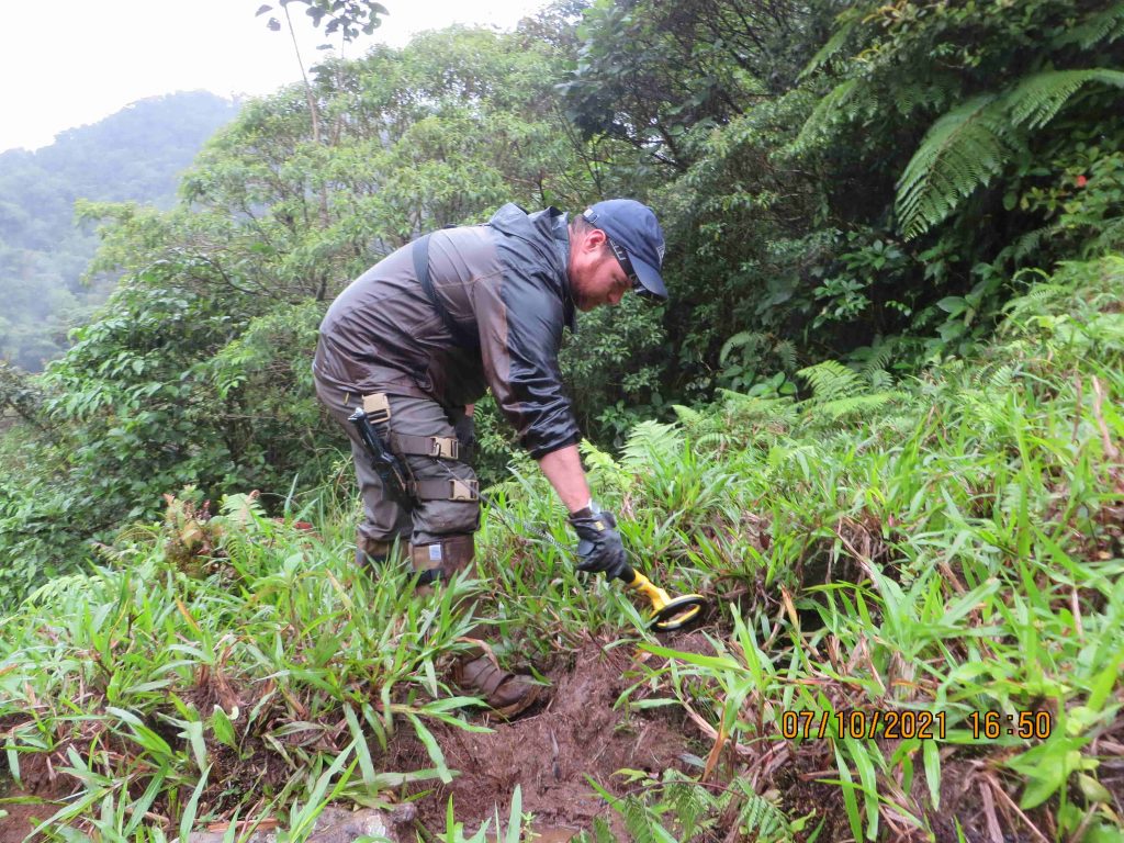
I continued utilizing the metal detector in areas surrounding the river bed, such as on the banks of the river and in muddy/grassy areas. Although the metal detector was excellent at identify iron in rocks, I came up empty handed regarding anything relating to the case, or anything manmade for that matter.
Conclusions & Takeaways
We were able to derive some helpful conclusions with our analysis.
Undoubtedly, the most important environmental data that we collected was the temperature data. Most important was the low-temperatures we observed.
- During our expedition we experienced night-temperatures as low as 14.8°C (58.64°F). According to historical temperature data, Kris and Lisanne could have faced low temperatures of approximately 14.44°C (58°F).
- The daytime air temperature recorded at the mirador was 15.7°C (60°F) during our expedition.
- Seeking shelter for warmth would have been a top priority for Kris and Lisanne, especially considering the light clothing they were wearing.
- The rivers were a safe drinking-water supply. Kris and Lisanne would have been drawn to the river(s) as a freshwater supply. If injured, it’s unlikely they would have risked leaving the river’s edge – freshwater would increase their chance of survival. People can survive for more than a month while consuming only water.
- Insects could have been the reason for their decision to limit night-time phone use. Insects swarmed our sources of light.
- The camera’s flash would have been advantageous to avoid attracting insects. However, flying-insect activity decreased as the temperature decreased at night. Spider activity increased at night.
- There’s less insect activity near the rivers.
- Fortuna Nature Reserve has an average temperature difference of +1.895 from the Pianista trail, which makes it a fairly reliable resource in estimating unknown temperatures on the the trail.
- The day-time temperatures are comfortable and cool-enough to void any concern of heat-stroke, especially considering that they weren’t carrying heavy gear. Cold temperatures would have been a much larger concern for them.
- With the high potential for wet clothing and cold night temperatures, hypothermia cannot be ruled out as a cause of death, but it does not answer why at least one of them did not return for help, nor why nobody found them on the trail.
- The rivers are loud and make it difficult to hear other sounds.
- The overall region where they disappeared experienced little to no rainfall during the first week of their disappearance.
- The first moderate rainfall happened the same day that the night-photos were taken.
- The rivers contain rocks with metal deposits. Metal detecting without advanced industrial equipment is not a reasonable endeavor to search the rivers for items. However, in non-rocky areas it’s still possible to identify objects using a common metal detector.
- More data from Fortuna Nature Reserve is necessary to evaluate Romain’s recorded temperatures.
That concludes this article. As always, we greatly appreciate the support of our followers.
Thank you for reading.
Please note: Our team is committed to accuracy of information and respecting the privacy of those involved with this disappearance case. If you have any supplementary information regarding the case, or if you were involved in this case and feel that the information available in this article impacts your privacy, please contact our team.
Excellent and insightful analysis
Thank you for your constant work on the case, collecting data and sharing detailed, valueable information.
Somewhere was stated, Kris and Lisanne were experienced travelers. But keep in mind they were just in their early twenties. Was this their first big travel so far abroad? I think they were quite inexpirienced and had a too light-hearted approach to the El Pianista trail, not aware there is literally wilderness right beyond the tourist city of Boquete.
Watching Romains clips of the hike is an eye opener, this is not the easy walk they were clothed, equiped and prepared for. Especially in rainy, wet conditions and beyond the mirador!
As a diver I am well aware of the threat of hypothermia and what a difference a temperature difference of one or two dergees Celsius really can make!
Outstanding research on the environmental influences and exposure the girls might have faced!
Hi Matt, Chris and Romain, regarding the weather app that is assumed to have been purposely opened and consulted by Lisanne, I believe that something else completely might have been going on.
The Galaxy phone has 3 opening pages that can be reached by swiping left and right, prior to logging in. One of those 3 pages is the accu weather app/page.
Who ever turns on the phone and does not know the log in pin code, can only swipe left or right and toggle between those 3 pages.
The person who switched on Lisanne’s phone, did not log in / insert the pin code and swiped to the left instead thus opened the Accu weather page. It is my understanding that that person did not know how to log into the phone and the only thing that person could do, is swipe.
Small chance that that person would have been the owner of the phone, i.e. Lisanne.
Not only, the Accu weather app does not update offline. Lisanne knew that. There’s no point of consulting the app offline after x days.
Whether rain was on its way or not at the time the app was opened, the app would not have been of any help at all.
If it rains, it rains. If it doesn’t, then it simply doesn’t. No need for an app that doesn’t even function.
The fact that the phone was not logged in to, and that the weather app page was swiped open instead, tells me that someone unfamiliar with the phone, had been handling it.
Why do I say this? Because the exact same happened to me. I have had to learn how the Galaxy works.
Hi,
You are almost certainly correct.
It was highly unlikely it was either girl due to what you highlighted.
The other striking thing is that although the girls made use of Google Maps to reach the Mirador, upon reaching the top, the app was switched off and was never switched on again.
Not one attempt to switch on the app, not even when they still had enough battery. As if the girls didn’t FEEL being lost.
They díd attempt to dial 112/911, but they didn’t attempt to orientate themselves by switching Google Maps back on.
Was that perhaps because they remained farely nearby the Mirador for the first 1-2-3 days? Hence no need for orientation?
Or perhaps because they were in company?
I think you guys have been doing an excellent job the way you have been investigating this disappearance case. Excellent analysis of the temperatures and rainfall.
One of the many interesting things is that the last “normal” photo #508, captured a temperature of 23C (the Mirador photos captured 22C).
At the time photo #508 was taken, Kris and Lisanne wouldn’t have had the need to look for warmer temperatures. Temperature wise, there was no objection to climb back to the Mirador.
The need for warmer temperatures would arise at sundown or at night. Question is: what happened to them between 2pm and sundown?
Nothing that helps to solve the case.
Why don’t yo focus efforts on locating night photos location? The big stone visible on these photos has distinctive remarks which will not get eroded and change quickly, unlike riverbanks or fauna. Why no one directed efforts in this ?
We have been for the night photos location but it’s not as simple as you appear to believe. I have visited the area many times. I have hiked through rivers and recorded a lot drone footage in hopes of identifying the night photo location. Yet, it’s not enough.
Finding the night photos location is like solving a puzzle. Every bit of information is necessary to put the pieces together, in order to narrow the area of search as much as possible. Instead of manually searching each square meter of every river, which is very dangerous, we must first determine where that location is most likely to be. We have been establishing a profile from the night photos, organizing data on the environmental conditions, piecing together the timeline information and noting the features. This will make it possible for me to establish a search route and an approximate search area.
Since you do not value our previous work in searching for the night-photo location, maybe you would be inclined to make a donation to support a new expedition? This work takes a lot of our personal time and money, not to mention the dangers and risks involved.
Hi Romain,
Thank you for the passion with which you have pursued this baffling set of circumstances.
Take care.
Thanks for the details. It will not help to solve the case directly but it certainly helps with a better understanding.
The cooler temperature at a higher altitude explained why K & L continued to trek up the summit without feeling uncomfortably hot on a sunny day.
Hi LatiLong,
Thank you for your comment. I agree with you that it will not solve the case directly. Unfortunately, solving the case entirely is very unlikely, unless someone involved in the case comes forward with more information or evidence.
With that said, still it remains possible to find new pieces of information, which could give us a better understanding of what happened. That is what our team continues to work on. Each piece of information gives us insights into the disappearance.
Thanks again for your comment,
Cheers