Update June 3, 2021: Romain launched his expedition article here for our French-speaking audience.
This is an update regarding our team’s planned expedition into the jungles of Panama to gather relevant missing information. We previously wrote about our expedition plans here (link). We are excited to announce that our team has made a lot of progress on raising funds and designing our jungle expedition.
The team has already overcome numerous obstacles in terms of designing our trip, creating safety plans (and contingency plans), as well as prioritizing gear and equipment requirements for our trip.
Our biggest hurdle is still Coronavirus.
Due to the ever-evolving Coronavirus restrictions and mandates by governments domestic and foreign, things remain on hold. Once governments and airlines lift all travel restrictions, we’ll choose our optimal travel date and start setting things in motion. Until then, we’ll be working to save money and eagerly waiting for things to clear.
When will we go? We still don’t know. Vaccines are still in the early stages of distribution in Central America, therefore they are limiting cross-border travel. Hopefully that will change this year.
Fundraising Update
So far our campaign has raised $1,223. We are thrilled to receive this much support and feedback from the public. Thank you to everyone that has donated money and provided words of encouragement. Your support gives us more inspiration and motivation.
For newcomers, here’s our campaign page: Mapping The Jungle Trails Of Panama
Romain also published a fundraising page in French too, for our European audience.
Many of our campaign contributors wish to remain anonymous and we 100% respect their privacy. We are so grateful to our contributors for putting their confidence in us. This trip is important to us and their support helps to reduce financial pressure. From our largest contributor ($500), to our smallest contributor ($10), we appreciate every dollar.
Filling In The Financial Gaps
We already know that we’re not going to be able to fundraise all of the money we will need. But that’s ok. We’re happy to have the opportunity to experience this journey with the support of so many interesting people. We’ve received emails from supporters and followers across Europe, Asia, North America, South America and many other places. It’s remarkable to see how much interest there is in our upcoming expedition. And we thank you all greatly for that.
Anyway, our team members will be covering the bulk of the financial requirements for this trip. Collectively, we’ve spent thousands of dollars and put in hundreds of hours planning the expedition.
Trip Design
Before diving into details our trip design, it’s important to briefly mention our approach. The disappearance case has three general theories: 1) the injured/lost theory, 2) the third-party theory, 3) the mixed theory.
Altogether, those three theories involve perhaps an infinite number of variables.
In order to ensure we stay focussed and utilize our time efficiently, we’ll only use case information that is 100% factual. Too much speculation about how they disappeared can derail our efforts and cause the team to lose focus. For example, if an animal attack took place or someone took Kris and Lisanne into captivity, we cannot speculate regarding those possibilities in our decision making process. Doing so could take us down a long “rabbit hole” and result in wasted time that we could otherwise use for other higher priority objectives.
In the end, we’ll be utilizing only factual information to determine our approach and decision making process.
Our trip design will be based on our objectives and our team strengths.
These are our main team strengths:
- Technology and expertise available to us.
- Our prior experience with hiking and trekking.
- Our experience living internationally and visiting Panama.
- Knowledge of security protocols and safety measures.
- Access to experienced professionals in multiple fields, like data analysis, imaging, security, tracking, medicine, psychology, etc.
- Utilizing existing case information to plan our routes and make decisions on the trail.
Team profile: Our team is now full. Everyone on our team is experienced with international travel (including in Panama), hiking in jungles and camping. We all have experience with the technology to a comfortable degree. Also, our team will be with a jungle survival expert that has experience with search and rescue missions.
Romain, Matt and I are coordinating the trip, with some additional team members that wish to remain anonymous. Matt will be coordinating our remote team to support those of us in Panama. Therefore, we’ll have boots on the ground in Panama and a remote team to ensure we have backup support as needed.
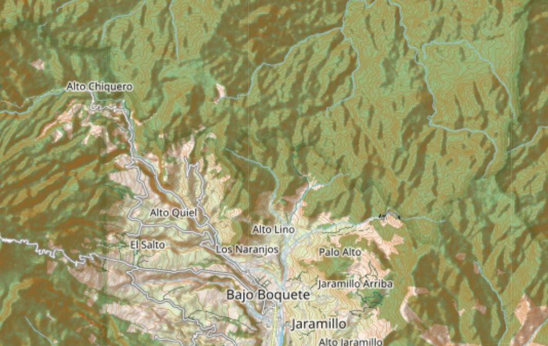
We are constantly reviewing the disappearance case information to ensure that our routes are planned properly. For example, we know that Kris and Lisanne’s items were discovered in the Serpent River downstream from multiple confluence points. Aside from speculation of how or why this happened, we know that our most likely chance for finding the location of the night-photos is by searching upstream in the shallow headwaters of intermittent tributaries that increase in water depth substantially with rainfall. Those factors, combined with other factors will be important during our profiling of the area.
Most data we gather will be recorded and mapped in real-time. That will limit the potential for loss of data. Some data will be dumped to remote servers as milestones are reached, for further evaluation later on. Our focus will be targeting our primary objectives and gathering the maximum amount of information possible. After our trip, we’ll have ample time to evaluate the data from the comfort of our homes.
Expedition Objectives
As discussed in previous updates, our team is well aware that it’s unlikely for anyone to “solve” this case. However, there are many unanswered questions that are still entirely feasible to uncover in the mountains north of Boquete. Not including all the planning involved, it’s relatively low-risk for us to fill in some gaps of their timeline, identify trails, find areas prone to increase injury and mark existing landmarks in the GPS.
Thanks to the data recovered from the phones and the data recovered from the camera, the new information that we gather during our expedition can help us piece together unknown details about the area where they disappeared. Instead of relying on random photos found on the internet, we’ll be going there to gather all of the precise information that we need in order to form stronger conclusions about the disappearance.
Our expedition will have two primary objectives:
Objective 1: Map the GPS Coordinates of all trails (and rivers) north of the Mirador.
Photo #508 was the last captured moment that Kris Kremers and Lisanne Froon were hiking normally, without any obvious concerns. Then, approximately two hours and forty minutes after Photo 508 was taken, they made their first distress calls on their cell phones. That means that somewhere within 2 hours and 45 minutes from Photo 508 something detrimental happened.
We plan to find out how far they could have travelled in 2 hours and 45 minutes. We plan to identify all trails and rivers they could have possibly taken during that span of time. Also, we will mark (in our GPS) all possible places where an injury could have occurred.
Objective 2: Find the exact GPS coordinates of the “night photo” location.
At this point, the location of the night photos is still unknown. Certainly, there are some photos taken by travelers and journalists that seem to somewhat resemble the area of the night photo, but nobody has ever duplicated the photos that specifically indicate the same positioning of the boulders. Those boulders probably still exist in the same formation, or at least a very similar formation.
Our team has painstakingly scanned maps of the region and conducted numerous late-night brainstorming meetings. We have a refined strategy planned for identifying the precise location of the night photos. Our specific plan is too involved to convey here, but here is a summary: Our strategy involves identifying regions in rivers/ravines that offer resemblances of key attributes found in the night photos. Those attributes, combined with other map indicators, essentially highlight the areas that we will be searching.
An additional benefit to our trip is this: After our expedition, future hikers that visit Boquete will have all the trails pre-mapped out. That will increase their safety and reduce the likelihood of hikers getting lost. However, we do not advise that anyone attempts to visit trails in Panama without being accompanied by an experienced and trusted tour guide. Our expedition will be dangerous. Our team will do professional training and will be prepared with emergency satellite communication. We’re taking every effort to reduce risk of injury and danger.
Contingent Objectives
We also have contingency objectives that we’ll prioritize as we gather information during the expedition. For example, if we find the location of the night photos, we already have a list of pre-planned tasks to perform in that specific area, such as taking photos and drone footage of the immediate area.
It’s impossible for us to list all possible contingency objectives here because there are too many variables involved.
Secondary Objectives
If we succeed with the primary objectives (and their associated contingent objectives), we’ll have other goals in place. Our secondary objectives will involve things like: floating a similar backpack in the river (similar to their blue backpack), logging river temperatures and velocity, and photographing the location where the backpack was found, etc.
During our expedition, being respectful to locals and the environment is of utmost importance. We do not plan to interview locals or disturb anyone that lives in Boquete. In fact, we hope to perform our tasks relatively quickly, in order to prevent any potential disturbances. We will not leave trash in the jungle and we will minimize our impact on the surrounding environment.
Jungle Gear & Expectations
Before stepping foot in Panama, we wanted to be sure that we arrive prepared. Although we still have a lot of gear to purchase, we’ve started the process of buying boots, backpacks and some electronics (all with rechargeable batteries).
Here are some examples of things we’re preparing for.
Jungle Boots: Jungle boots are not the same as normal boots. Waterproof boots retain water and can lead to trench foot and tropical ulcers (aka “jungle rot”). Boots that breath are key. Our boots must be designed to purge excess water, otherwise you’ll be sloshing around in a liter of water as you’ll hike. Any boot insulation will make hiking unbearably hot and can increase risk of fungal infection. Furthermore, jungle boots often have a specialized sole, called the “Panama Sole”, which is specifically designed to prevent mud from compacting on the bottom of your boots. Here’s a great read on jungle boots.
Sleeping in normal tents is too risky. Panama is loaded with venomous snakes and fugly spiders and scorpions. I already experienced being stung by a scorpion in El Salvador – not fun. So, how will we avoid getting stung when sleeping in a tent? By sleeping in hammock tents. Here’s a great example of a hammock tent.
The sun is unreliable to solar-charge our electronics. We may need to charge our batteries because most of our work involves electronic gadgets. Drones, mapping systems, GPS devices, power banks, etc. But the sun might not always be present in the high elevations of the continental divide. So our team has decided to purchase a portable water turbine to charge our electronics in a pinch. It’s not a perfect plan, but if we’re deep in the jungle and need a charge it’ll be handy.
Our biggest danger. You might think our biggest risk is snakes, pumas or spectacled caiman. In reality, our biggest danger is falling trees. Day and night, trees fall in the jungle, and any disturbances from hikers makes it more likely for a dead tree to fall in your path. Therefore, we must constantly be aware of falling trees and falling branches as we hike.
Those are a few examples. There’s a lot of considerations to balance.
Update Summary
So, that’s all we have for now. Thank you again for the support and words of encouragement. We’re still purchasing gear and working to save money. We’re looking forward to heading down to Panama and gathering all of this information after Coronavirus restrictions are more lax.
Feel free to post comments below, but please limit any questions to only non-intrusive questions that won’t potentially involve the security of our team (ie, no questions about when we’ll go, where we’ll go or who will be attending our trip). I apologize in advance for any slow response times – everyone on our team has normal jobs and life to tend to. We’ll do our best to respond when we have free time available.
Thank you again to everyone that supports our efforts. And thank you to all of our wonderful team members that have worked hard to plan and organize our expedition.
Helpful links to our past articles:
All Case Articles: Kris Kremers & Lisanne Froon Case Articles
Last Team Update: Research Team Update – Support Us (From Dec 9, 2020)
Matt’s Recent Article: Items Uncovered: Backpack & Contents Analysis
Full Case Story: Unsolved: Kris Kremers And Lisanne Froon In Panama
Hi Chris,
Yesterday, I posted about my own travel experiences in this area in 1997 and 2010, but especially in 1997, when I traveled there with a guide at a time when western hostel and backpacker culture had not yet reached the area. I wanted to tell that story to start with to show, for the armchair criminologists on these forums, that I really have traveled in this area, including in the jungle to the north of the continental divide. I assume my comment is awaiting moderation.
Perhaps, when you do moderate, you could add this as a comment after my previous post. When you discussed the threat of animals, you focused on the charismatic megafauna that are rarely seen, not on the real everyday threats. Anybody spending several nights in the Panama jungle would come across these things. The jungle was overrun with thousands of species of insects, some of which could kill you. If you slept on the jungle floor, you might be overrun by a colony of soldier ants, which sting with an acidic venom and swarm in immense numbers over your body if you get too close to them. Another insect I heard about, and saw evidence of, was a fly that lays eggs in your skin. Its larva then burrow underneath your skin, living with you as the host for many months, until they finally emerge as adult flies. I saw the welts that people had from these flies.
At one point on the trail from Cerro Punta down into the Changuinola Basin, My guide Pedro pointed out a dead snake on the path, one that looked like what I would have called a coral snake, although he had a different name for it. Pedro remarked, in Spanish, \”If you are bitten by one of these, not even God can help you!\”
The trails that Pedro and I were using, which he knew very well, even though he had never seen a map, were used by local people, both Latino and Indigenous, to travel into and out of the region, since there were no roads. Pedro told me about the rail to Boquete, which he described as kind of the main highway of such trails. He said that the Ngobe, even though they are of very short stature, carry enormous loads into and out of the jungle, bringing out articles of trade such as handicrafts, and bringing back huge quantities of supplies.
Some of the armchair criminologists have asked, how could they be lost on this trail. I can tell you, from personal experience, that you could be only a few feet away from the trail and not even know that it was nearby. The jungle was that dense! The bread and butter of Pedro\’s guide business was taking people back and forth between Boquete and Cerro Punta, a one day hike on the Los Quetzales trail, the most famous trail in the region. I asked him, was it really necessary to have a guide? He told me that people go out on the trail and become disoriented and forget even which direction they are going on the trail. Sometimes they turn around and end up back where they started.
I can imagine the young Dutch women passing the divide and believing for at least a time that they were on their way home. For a gringo or European traveler, the jungle of Panama is very disorienting because the sun overhead does not work for you the way you are used to to give you a sense of direction.
When the Ngobe people travel over these trails, they travel in groups, and they appeared to have a network of small shelters that a family could use to spend a night. Pedro pointed one out to me just off the trail, although I would never have seen it without his help. So I reject the implausible theories of criminality, cannibal cults, gangs, and so forth. I think they fit a \”Heart of Darkness\” narrative that some westerners like to believe about developing countries. Of course, part of this narrative is a message to women that the world is too dangerous a place for them, and they should not be out traveling in places like this.
Although Panama is not nearly as wealthy as the USA and has terrible inequality, the standard of living among the Latino (Spanish speaking) population in Panama is roughly comparable to the United States in the 1950s, southern Europe in the 1960s, or Eastern Europe in the 1970s. People have televisions, smart phones, consumer electronics, and other things that we have, and many families have cars too. They just don\’t have the fancy brand name things that we have in the USA. I imagine this standard of living as being similar to that China as well. Everybody has enough to eat.
I don\’t doubt that there is now some gang activity in Panama, but the last place a gang would want to be active is in the Chiriquí highlands, which is far away from any place to engage in any kind of trafficking. I believe that Chris and Lisanne got lost, and had one of more accidents as they panicked in the woods, until both of them eventually perished. What a tragedy, but I hope people will not be afraid to continue traveling to Panama. It is a safe country if you use good judgment.
Howard
Hello Howard, I’ve never been to the area where the girls disappeared. What has puzzled me is…if they were lost on the wrong side of the divide why they didn’t at least go UP towards the crest of the divide. From what you posted…are you saying they might have got disoriented near the summit, thought they were on the correct slope, and then headed too far down the wrong slope in the mistaken belief they were headed back to Boquete?
That’s very plausible especially if one is not paying complete attention to surroundings.
I totally agree that cannibals, organ thieves, sex traders, etc is the product of people watching too much TV. However, I can’t regard criminality as implausible. Hopefully, the team have learned info on the trip that will persuade us one way or the other.
Thanks,
John
Hi Chris,
Good initiative! I have a couple of questions:
– Is it possible to make a donation without a credit card? I’m Dutch and in the Netherlands we have a debit card online payment system called Ideal. So a lot of us don’t own credit cards.
– I also have a slight request. On the top of the Pianista there is a memorial sign to Kris and Lisanne. On the sign the family name of Kris is spelled wrong. It says ‘Kremer’ instead of ‘Kremers’. Would it be possible for you to add the letter S to her name? The mirador should be on your route as a starting/end point for mapping the serpent trail. It would only take a minute to glue a laminated label. It’s a memorial sign, so the name should be spelled correctly.
Hi Chris. I’m new to this case and i ‘m so interested about this, i don’t know why. The whole story, the possibilities, the proofs, the characters, everything attracts me. Can you provide me an article or a link where i can learn the timeline of this case from Day 1? Really appreciate this. I wish you and your team good luck.
I’m a freelance journalist and just found this case. It’s heartbreaking and I do wonder if the families know more than they are at liberty to say? Have people reached out to their families? Out of respect I mean. While we all find this a puzzle to work out, we have to remember that these girls have families and we need to respect their feelings.
From what I’ve found, it’s hard to know what happened if we go by facts. My biggest worry is that Lisanne is still possibly alive, if all that was found was her foot. You can live without a foot.
Rumors are abuzz that photos of the girls dead are on the dark web, which would be heartbreaking but follow something I read that the families and Panamanian government intentionally deleted photo 509. Again, I would respect this as no parent or human would want that. Ever.
What I’m mystified with is the lack of research into the other bones found, not belonging to either girls in that river. No one even testing to see who they belong to?
I would venture to guess, the tour guide knows what happened—either he or his son are involved. The girls allegedly had an altercation with F’s son in a pharmacy the day before they went missing, and mysteriously that footage on the security camera went missing.
One thing: Did anyone try to contact the girl who was at the language school—Evelyn I think she was called—who went with F the next day, to the girls’ home where they were staying. She apparently took off soon after that, never to be heard from again. I think she might know something and that may be very helpful into finding out if these girls were set up from day one, or if this was just two girls in the wrong place at the wrong time.
Be safe in your travels!
Will you guys also try to find and inspect The Cave of La Pandura where a plastic bag with food packaging, insoles matching the exact colors of Lisannes shoes and a hair were found on 11th April 2014?
I mean you probably already know all the stuff. Just to make sure.
Juan has a video for it: https://youtu.be/MdXgoIiYJqQ
Hi Timo, thank you for your message.
I previously looked into the location of where the “Romero” grocery bag was found, and the coordinates I have are 8.8200, -82.4400.
Our team has a lot of other higher priority tasks, but I’ll re-mention this to the team. Perhaps we can visit this location, although I’m not sure if the reasoning is strong enough. This location is on the southern side of the Continental Divide, which is the opposite side of the mountain range from where the rest of the items were found. We’ll see.
Thank you and cheers.
Hi. Fantastic job on your blog, info sorting and dedication. I have only learned about this case recently. Question about the trails you want to map: i read on a travel blog that the pianista crosses the cont. Divide and then can be walked all the way to boca. Is that accurate or possible? I cannot pull up a map. Secondly, juan seems to have said on a video that the mother of osman said there were other photos of the women on his phone after he died. Is that accurate? I did not see a resemblance tho in the 1 picture shown. Third, is it accurate that bikini swimsuits were never found? Here is 1 more fictitious scenario: there is no place to get lost between final daytime pic and point of first emergency call. There, they meet 2 nice looking young men on the trail. They exchange phones to take each others pictures, but already thinking ahead one male dials the emergency number instead of clicking pic, knowing there is no signal. Why don‘t you hike with us, we can take each others pics? That would explain the confusion why no photos were taken at scenic locations after final daytime picture. I suppose there are endless scenarios
He says later, hey give me your home mothers phone number and i will hike out to where i can call her for you, no problem. One guy was a goner on the day the pin number was not entered?
Hi Fonte,
Thank you for your comment. I’ll do my best to answer your questions.
1. It depends what you’re referring to. The Bocas Del Toro Province is immediately north of Chiriquí Province, therefore passing the Mirador would essentially mean you’re in “Bocas”. However, if you’re referring to the island of Bocas Del Toro (technically, the capital of the Province), I imagine that it’s possible to hike all the way there after passing the Continental Divide, but it would take numerous days and numerous terrain hurdles to overcome. Many indigenous tribes live further north, including beyond Alto Romero, therefore it’s likely they have pre-established paths and unmarked trail systems. Without trails and maps, it would be incredibly difficult, likely impossible, for any non-professional hiker to navigate to Bocas Del Toro.
2. I do not have any information about Osman, nor his family, aside from what is available from public sources.
3. Correct. Bikini swimsuits were not found. I believe some people have speculated that the swimsuits were inside of the hostel where the girls were saying, but I can’t confirm the accuracy of that.
Regarding your final comments – I’m fairly open minded to various possibilities of what could have happened. In the end, nobody knows at this point and we can only speculate. You may be right, however, there are numerous theories about what may have happened and it’s impossible to know for certain. That’s why our team is always working to gather further information.
Thank you for your comment and cheers.
Cheers! Cannot wait to see what you discover with your expedition, especially from the place of the final daytime photo to the distance that could possibly be hiked up til the time of first emergency call.
Hello Chris,
are you going to look for the stream crossing in photos 507 and 508, or do you assume that the stream crossing that RomainC reached during his hike beyond the Mirador (https://www.youtube.com/watch?v=Fd7isUH2aZI) is the correct stream crossing?
In my opinion, the stream crossing in photos 507 and 508 is somewhere else. The stream that RomainC reached is probably the same, but the stream crossing is different.
The film (https://www.youtube.com/watch?v=gnfol1KfUPc, from 3:50 to 4:00) probably shows the stream crossing we are looking for. Here is the link https://andrzejbystrzycki.github.io/crime/froon_kremers/quebrada1/quebrada1_3.html where you can find some shots from the film. The distinctive features are marked in some photos. The stone at which Kris stands in photo 507 is marked in red. The large leaves of a plant are marked in blue. The rock on the other side of the stream crossing is marked in pink. Notice that the man in the film is standing on the other side of the stream crossing. There is also the distinctive path at the rock that leads up a hill. It is clearly visible in photo 508.
The photos on the website are organized as follows: the shots taken while the camera is moving vertically are arranged vertically; the shots taken while the camera is moving horizontally are arranged horizontally. The photos overlap each other both vertically and horizonatlly.
I have been researching the case for 2 years. This is my website where I gathered the results of my research: AndrzejBystrzycki.github.io
Hi Chris, why can’t you post the non-leaked pictures? Do you plan to show that one day?
Good afternoon Josas,
At this time we are not allowed to publish those photos. Perhaps someday our sources will permit us to publish them. Thank you for your question.
Cheers
I think you should try to make your trip roughly at the same time girls went missing. So the surroundings, vegetation, climate, temperatures, water levels etc. would be somewhat same (?)
Hi Maya, thank you for your comment and interest in our work.
I’m not sure what your specific question is. Either way, you mention a good discussion point.
There are certainly different approaches to determining the best time to visit Boquete to conduct the research. Kris and Lisanne disappeared in April, then their items were found in the river over the following 5 months. The rainy season usually starts mild (in April/May) and slowly increases as fall approaches, with the heaviest rain happening in September/October. As mentioned in the article, we won’t be able to discuss our trip timing in detail. However, we’re aware of the factors and considerations that are involved in deciding when to go: the case details, the seasons, the river activity, etc. We also have other constraints as well, such as Covid. We’re balancing a lot of variables to choose an optimal travel time.
Thank you again for your comment and cheers!
Hi Chris
I accidentally stumbled across a youtube video and a subreddit that covers this case.
I was in Bocas del Toro exactly one year later and all the speculations on youtube brought up memories. There were a lot of speculations back at that time. I heard a lot of people talk about an animal like a Jaguar or something like this.
I wish you good luck. Hopefully you’ll find out more.
Cheers
Thank you for your support Enrico! It’s possible that an animal of some sort was involved. We’re doing our best to ensure that our expedition will be productive. We’re confident that we’ll be able to fill in some gaps in the case timeline.
Cheers
Hi Chris.
Think about taking a multi-frequency/multi-constellation GNSS receiver to your expedition. It will make much more precise location measurement under tree canopies.
I’m a jungle survival instructor in Brazil and in our tests with low-cost GPS receivers we were able to see errors of more than 200mts in horizontal readings under dense tree canopy.
Good luck!
Hi Rooster, thank you for your input.
I looked into this a little more after you mentioned it and we’ve reviewed the GPS technical details thoroughly. Matt from our team is very knowledgable of GPS devices and is guiding us through the process of making an informed purchasing decision.
While everyone on our team is frugal with the cost of gear purchases, our GPS’s will be vital to the objectives of the trip and to our safety, so we’re cautious in balancing reliability, functionality and cost.
Each GPS that our team will bring offers slight variances in operability, therefore diversifying our options for satellite connectivity, mapping, routing, messaging, battery life, etc.
We will test each GPS under numerous conditions before embarking on the expedition: cloud-cover, rain, fog, tree-cover, remote areas, etc. If there are any issues, we’ll surely evaluate potential fixes.
Thanks again and cheers.
Good luck, it’s a marvellous thing you’re doing. I’m sure Kris and Lisanne would appreciate it.
Thank you for your support Richard!
Good day
If the situation permits, you may wish to trek the Rio Chiriqui Nuevo at the Caldera Hot Springs and the Macanito Rocks.
The Macanito Rocks are almost certainly the location of the swimming photo which the 2 girls appear to have swam there.
This has been highlighted by Scarlet.
Hi lati long, thank you for your suggestions. We’ll be carefully balancing multiple priorities. If we have the opportunity to search for the Macanito Rocks without delaying the other priorities, we’ll certainly do so.
We review Scarlet’s work occasionally and she’s done a great job at discussing the bulk of the case information.
Thanks again and cheers
Hi
How many drones (model)do you have/need and how/what data are u storing? – how to upload to servers considering the remoteness of the area.
How are you planning to map the area given an average flight time of 30 minutes doesn’t make it easy to cover a large area once the direct vicinity of the camp has been mapped
Hello blublub, these are great questions.
1. Our team is bringing two drones, one of which will be backup. Our main drone is the Mavic Air 2S which has a flight time of ~35 minutes under optimal conditions. We’ll be waterproofing both drones to withstand humidity and moisture in the mountains. In terms of data, we’re storing 4K video on numerous SD cards.
2. We’ll upload mapping data in real time with the satellite GPS devices that we’ll be carrying. Unless we find a way to remotely upload the video we capture in the jungle (probably not possible), we’ll just plan on dumping the footage to our servers during our downtime back in Boquete. This expedition is expected to take multiple trips back and forth into the jungle.
3. Mapping the area with limited drone flight-times/battery will indeed be a challenge. We’re bringing numerous batteries and devices to recharge those batteries. However, keep in mind that we won’t be flying the drone all day. To cover a large area isn’t really necessary. We only need to cover specific areas and some long strips of river. The drones will primarily be a tool to help us map rivers and trails that are otherwise difficult to capture with our handheld cameras.
Thank you for your questions and cheers!
Hi, thx for the reply
Since no one knows where the nightly location was and given over 7 days as a time span the area to cover is quite large, maybe Ven larger than what you plan to look at – so the best way to cover as much ground as possible in a short time are the drones – then after you have mapped as much as possible it’s time to get to the interesting places by foot, traveling by foot along the rivers will take more time than flying, so again I think dries are you best option.
To maximize flying time you need a battery mod:
https://m.youtube.com/watch?v=T7_HUGMu-PQ
This looks to be easily done without opening the original battery , so there is no risk involved in fucking up the drone.
I made a donation today to give u some more options financially, use it as u like but I suggest getting another drone, spare parts or battery/off the grid charging option
Hi blublub, please check your email when you have a moment. I provided a little more detail into the drones we’ll be using.
And thank you so much for your contribution! We definitely appreciate it.
It is worth taking a look in the Caldera Hot Springs area. It is possible that they were abducted there.
Hi Mike, thank you for your comment.
This a is a great point. There are several areas, including the Caldera Hot Springs, which our team hopes to visit. We’ve deemed our first two objectives to be a higher priority, but we certainly recognize the importance of visiting the Caldera Hot Springs area as well.
Cheers
Good day
If you are able to visit the Caldera Hot Springs, please do not forget about the Macanito Rocks which is almost certainly the location of the swimming photo.
If you can, please try to measure the various depths of the Rio Chiriqui Nuevo at Macanito Rocks.
The photo suggests when the water level is higher, it reaches to the waist level of an approximate 173 cm tall man.
have u checked in with Scarlet and Juan?
Scarlet:
https://koudekaas.blogspot.com/2019/12/the-disappearance-of-kris-kremers-and.html
Juan’s google album
https://photos.google.com/share/AF1QipOaDcK-zyudR_UXP4xNvvSpKhbEUNHFkl1cvaGaZrvkiKqkgSL0BK5mjUL2SGcDjw?key=UjkzUHpsRmtLNUc2RlphdjVTWHRZSVEySjNYS0NR
They are the two best sources of information I have found for this case….
Hi Sean, we’re definitely aware of the work of both Scarlet and Juan.
They’ve been writing about the case and keeping notes/records for a very long time. Their records, screenshots and notes have been helpful at times and we’ve linked to their work in some of our articles.
Also, Juan and Scarlet were both integral for keeping the case alive during previous years when interest in the case slowed.
Thank you for your comment and cheers
Juan is a nutter that’s profiting* from far-out theories while accusing various people of murder; these people have no possibility to defend themselves in any credible way. If anyone makes this point on his channel then the comment is deleted. Yes, he kept the case alive, but for his own sake.
*I assume. His YT channel offers a membership option over and above what he may earn from views.